
Aerial Mapping & Photogrammetry
Photogrammetric mapping, vertical and oblique aerial photography, colour and multispectral orthophoto and GIS — with the Leica DMC250, one of the world’s best systems, approved by the Survey of Israel.
What are aerial mapping and photogrammetry?
Photogrammetry is the science of measuring from photographs. Overlapping aerial images, captured from an aircraft along planned flight lines, allow the terrain to be reconstructed in 3D and turned into accurate maps, models and geographic deliverables.
In recent years Hetz Hazafon has provided extensive aerial photography for the State of Israel through the Survey of Israel, as well as photography services for other survey firms.
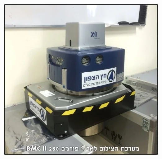
The equipment: Leica DMC250 by Hexagon
A large-format digital aerial camera system, among the best in the world for precise photogrammetric mapping. It was approved by the Survey of Israel for precise engineering mapping at 1:250 scale, grade 3, quality class A. It delivers aerial imagery for accurate mapping, colour orthophoto and 4-channel multispectral imaging, including NIR.
A medium-format Leica RCD30 serves as backup; it too is approved by the Survey of Israel and is flown routinely together with the LiDAR system.
Photogrammetry and aerial photography services
- Photogrammetric mapping for town plans and urban-renewal projects.
- Vertical and oblique aerial photography for planning.
- Drone aerial photography.
- Geographic information systems (GIS).
- Colour and multispectral orthophoto.
- Airborne LiDAR scanning for topographic and bathymetric mapping.
- Bathymetry, visualisation and modelling.
- Aerial photography for documentation and supervision.
Workflow
The process covers flight planning, image acquisition, ground control, aerial triangulation, production of the model and orthophoto, and a thorough quality control before delivery. Working alongside the company’s surveying and cadastre departments lets us run a project from start to finish under one roof — with no subcontractors.
A dedicated fleet
The equipment is permanently installed in twin-engine Piper Aztec aircraft with large photo openings and enlarged fuel tanks (over 6 hours of continuous flight), so the company is available immediately for any mission — at low and high altitude. Read more about our equipment and fleet.
Frequently asked questions
What is an orthophoto and how does it differ from a regular aerial photo?
Which camera does Hetz Hazafon use for aerial photography?
Where is aerial mapping used?
What is multispectral imaging?
Can mapping be combined with ground surveying?
More services
Interested in this service?
We'll accompany you from planning to final deliverables.